North Kaibab Trail
"The prospect of a snowstorm grew more and more
imminent... we were forced to consider a retreat to
the south... Bright Angel Canyon beckoned to us as
a possible avenue, and eagerly we scanned its sides
for a practicable way down."
Frances E. Matthes, U.S. Geological Survey, describing
the first recorded use of the route that became the
North Kaibab Trail.
Winter caught Francois Matthes
and his survey crew on the North
Rim in 1902. They needed an escape
route south, but none were known.
Matthes chose Bright Angel Canyon,
and their arduous course to the
Colorado River became the basis for
today's North Kaibab Trail.
Indians had used Bright Angel
Canyon for centuries. Prospectors
had gone that way, too, but their
journeys were unrecorded. The route,
as Matthes later noted, "is carved
along a great fracture in the earth's
crust, a fault." This great fracture,
Bright Angel Fault, has enabled men
and mules to enter Grand Canyon.
Use of the route began slowly;
extensive trail work did not
begin until the national park was
established in 1919. Today, after
decades of toil, Matthes' escape
route is used by thousands of
visitors each year.
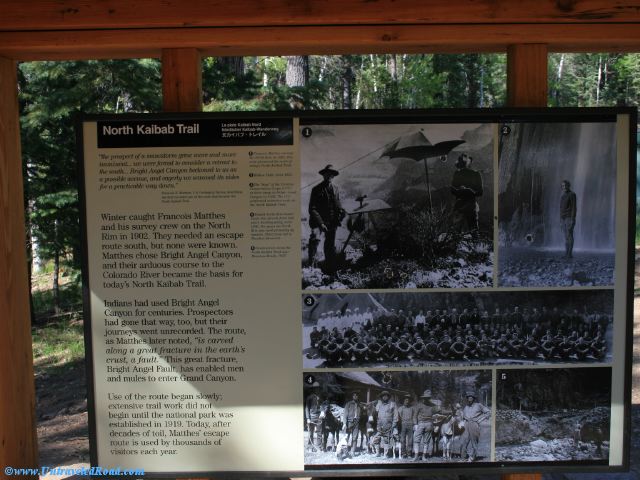
1. Francois Matthes surveys
the North Rim in 1902. His
crew pioneered the route of
today's North Kaibab Trail.
2. Ribbon Falls, circa 1925.
3. The "boys" of the Civilian
Conservation Corps (CCC)
at their camp in Bright Angel
Canyon in 1936. The CCC
performed extensive work on
the North Kaibab Trail.
4. Famed North Rim hunter
Uncle Jim (fourth from left)
and a hunting party, circa
1900. For years the North
Rim was used primarily by
hunters. Third from left is
Theodore Roosevelt.
5. Construction along
the North Kaibab Trail near
Phantom Ranch, 1937.