Entry Points:

About North Rim
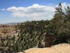
In 1928, the Grand Canyon Lodge on the North Rim was opened, situated atop cliffs near Bright Angel Point, at the edge of lush ponderosa forests. It's higher altitude brings heavy winter snows, feeding beautiful alpine forests and meadows, and making it much greener than areas on the south rim. However, along with the snow, and the long crossing of the Kaibab Plateau, where Arizona Highway 67 climbs as high as 9,000 feet, the North Rim stays a more remote and less frequently visited portion of the park.
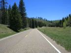
Unlike the south rim, where paved roads parallel the rim for many miles, the north rim's irregular shape doesn't allow easy access by road to a lot of the rim. State Highway 67, approaching from the north, leads directly to Bright Angel Point, where the lodge and visitors center are located. A left-hand turn a short distance before this, puts you on Fuller Canyon road, which accesses Imperial Point and viewpoints on the Walhalla Plateau. Access to other North Rim viewpoints is either by trail or 4-wheel drive roads.
The Colorado River makes a wide, circuitous path around North Rim. Approaching from the northeast, it flows nearly southward until it rounds Cape Royal at the tip of the Walhalla Plateau. From there it turns nearly due west, passing south of Bright Angel Point. Some distance further west it makes a large bend northward, enclosing North Rim on three sides.
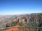
Bright Angel Point, which is situated further from the Colorado River than most south rim viewpoints, overlooks Bright Angel Canyon, one of the longest tributary canyons to the Grand Canyon. The Kaibab Trail makes the descent to the river via this canyon, and is a popular and demanding hike at North Rim. Camping is available at Phantom Ranch at the bottom of the canyon, and hikers can continue up to the south rim via the South Kaibab or Bright Angel trails.
The Walhalla Plateau is a section of the rim nearly isolated from the rest of North Rim by the Bright Angel Canyon and others. Fuller Canyon Road makes a winding journey out to this plateau, ending at Cape Royal. The only views of the Colorado River at North Rim are from Cape Royal. Walhalla Plateau extends much further south than Bright Angel Point.
As you leave the National Park's northern boundary on Highway 67, a sign proclaims the distance to South Rim to be 204 miles.