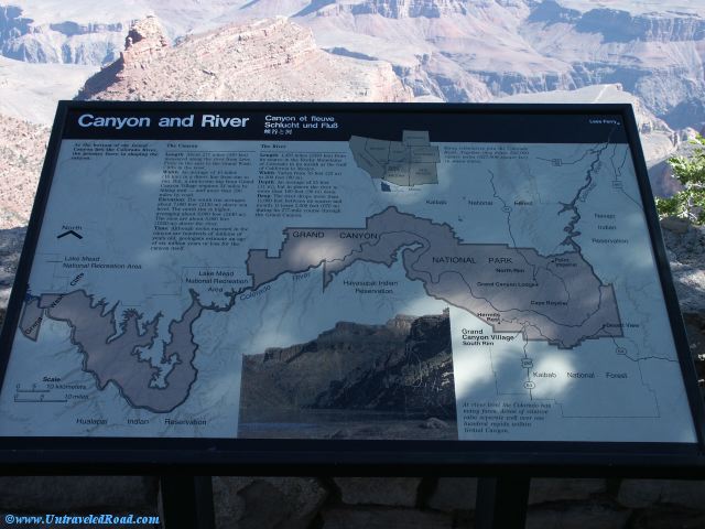
Canyon and River
At the bottom of the Grand
Canyon lies the Colorado River,
the primary force in shaping the
canyon.
The Canyon
Length: About 277 miles (450km)
measured along the river from Lees
Ferry on the east to the Grand Wash
Cliffs in the west.
Width: An average or 10 miles
(16 km) in a direct line from rim to
rim. But, a rim-to-rim trip from Grand
Canyon Village requires 24 miles by
hiking trail - and more than 200
miles by road.
Elevation: The south rim averages
about 7,000 feet (2130 m) above sea
level. The north rim is higher,
averaging about 8,000 feet (2440 m).
The rims are about 5,000 feet
(1520 m) above the river.
Time: Although rocks exposed to the
canyon are hundreds of millions of
years old, geologists estimate an age
of six million years or less for the
canyon itself.
The River
Length: 1,450 miles (2350 km) from
its source in the Rocky Mountains
of Colorado to its mouth at the Gulf
of California in Mexico.
Width: Varies from 76 feet (23 m)
to 300 feet (990 m).
Depth: An average of 35 feet
(11 m), but in places the river is
more than 100 feet (30 m) deep.
Drop: The river drops more than
11,000 feet between its source and
mouth. It loses 2,200 feet (670 m)
during its 277 mile course through
the Grand Canyon.
Many tributaries join the Colorado
River. Together they drain 242,000
square miles (627,000 square km)
in seven states.
At river level the Colorado has
many faces. Areas of relative
calm separate well over one
hundred rapids within
Grand Canyon.


Don't miss the rest of our virtual tour of Grand Canyon National Park in 10803 images.