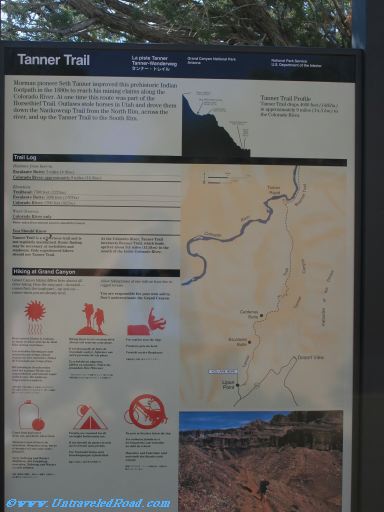
Tanner Trail
Mormon pioneer Seth Tanner improved this prehistoric Indian
footpath in the 1880s to reach his mining claims along the
Colorado River. At one time this route was part of the
Horsethief Trail. Outlaws stole horses in Utah and drove them
down the Nankoweap Trail from the North Rim, across the
river, and up the Tanner Trail to the South Rim.
Tanner Trail Profile
Tanner Trail drops 4600 feet (1462m)
in approximately 9 miles (14.5 km) to
the Colorado River.
Trail Log
Distance from here to:
Escalante Butte: 3 miles (4.8 km)
Colorado River: approximately 9 miles (14.5km)
Elevation:
Trailhead: 7300 feet (2225m)
Escalante Butte: 5600 feet (1707m)
Colorado River: 2700 feet (822m)
Water Sources:
Colorado River only
Water taken from natural sources should be treated.
You Should Know
Tanner Trail is a wilderness trail and is
not regularly maintained. Route finding
may be necessary at rockslides and
washouts. Only experienced hikers
should use Tanner Trail.
At the Colorado River, Tanner Trail
intersects Beamer Trail,w hich leads
upriver about 9.5 miles (15.3km) to the
mout of the Little Colorado River.
Hiking at Grand Canyon
Grand Canyon hiking differs from almost all
other hiking. Here the easy part—downhill—
comes first; the tough part—up and out—
comes when you are already tired.
Allow hiking times of one mile and hour due to
rugged terrain.
You are responsible for your own safety.
Don't underestimate the Grand Canyon.


Don't miss the rest of our virtual tour of Grand Canyon National Park in 10803 images.