Entry Points:

About Navajo Bridge
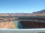
In nothern Arizona, the Grand Canyon cuts through the middle of a flat valley rimmed by the pink-colored Vermilion Cliffs on the west and the Echo Cliffs on the east. At the canyon's edge, the ground abruptly gives way to sheer cliffs walling in the Colorado River hundreds of feet below. The chasm, which deepens and widens as it continues southward into Grand Canyon National Park, formed a formidible barrier to transportation and exploration.
In 1927 crews began construction of the 834-foot long bridge over the chasm, supported by a wide arch of steel beams fastened into the tops of the chasm's walls. The river lies 467 feet below. In 1995 the original bridge was deemed inadequate due to its narrow width and limited load capacity. A new bridge was built next to the original, matching in style, but large enough for today's truck traffic. The original bridge has been preserved as a footbridge.
The Navajo Bridge is the only highway bridge on the Colorado River from Glen Canyon Dam to Hoover Dam, a distance of some 600 miles. Before the construction of the bridge, a ferry was available at Lee's Ferry, a short distance to the north.
Street Index
|
a sidewalk a turnout Colorado River Marble Canyon |
Navajo Bridge old road U.S. Highway 89A |